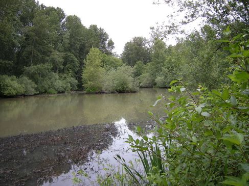
What remains of the Black River; an indentation on the east side of the Green River in Tukwila, near Fort Dent Park. (Wikimedia Commons photo by Joe Mabel)
Living in Western Washington, there are aspects of the landscape that feels like they were always there, even if they have been altered greatly by man.
The most obvious, of course, is the Lake Washington Ship Canal in Seattle. That’s been there for almost a century, and few (if any) are around who know what Montlake and Fremont looked like before those cuts were made. While it’s tough to think about what those areas looked like before the canal was built, it is much easier to imagine what Lake Washington looked like before the canal built.
The ship canal dropped the level of the lake by nine feet, drastically altering the shoreline and its entire ecosystem. Where the lake had previously drained to the south through the Black River, it now drained west through the canal to Lake Union, Salmon Bay, Shilshole Bay and Puget Sound.
The Black River? Yes, the Black River. It was a fairly short river, draining Lake Washington from Renton to Tukwila, where it merged with the White River and became the Duwamish River. The Black River also was where the Cedar River flowed into south of the lake, meaning the Black was the outlet for two major regional drainage systems.
But, unless you know where to look, there is no more Black River or much sign that it was there. First, Renton diverted the Cedar River into Lake Washington in 1912 to try and prevent a repeat of a major flood that hit the city in 1911 (that’s why, when you look at a map, the last mile or so of the Cedar is very straight). Then, in 1916, the ship canal opened, shifting the lake’s outlet from the Black River to Montlake Cut. That dropped the level of the lake below the level of the Black River, causing the river to dry up. There is a small area near Fort Dent in Tukwila where you can see an indent in the (current) Green River’s east bank, which is where the mouth of the Black River once existed. Otherwise, one may never know there was any evidence of a major river that no longer exists.
The lowering of the lake didn’t just affect the south end. The water flowing through the Sammamish River started to increase, as there was now a bigger elevation difference between Lake Sammamish and Lake Washington. The mouth of the Sammamish, which had been near Bothell, shifted west to a point closer to what is now Kenmore and that is the river mouth that we are familiar with today. It also ended the bulk of navigation on the Sammamish, which had been able to carry boats between the lakes before the ship canal opened (and had been dredged regularly, and curves softened, to keep that traffic going). While the major cosmetic change for the river came in the early 1960s, when King County straightened out the Sammamish between Redmond and Woodinville to control flooding, the Sammamish was forever changed by work done decades earlier.
Then there is the White River. What you know as the White River today isn’t the one that originally existed, at least the portion in King County. It originally ran north through Auburn, Kent and Tukwila before combining with the Black River and becoming the Duwamish for the last part of its journey. The Green River flowed into the White at Auburn, and the White carried the Green’s waters, along with its own, to the Duwamish.
But a combination of nature and man drastically changed the White River in the early part of the 20th Century. After years of logjams and flooding that had farmers in King County trying to divert the White into Pierce County, and Pierce County farmers trying to keep the White on its original course, a major flood in 1906 made the final diversion of the White River into the Stuck River permanent. That meant all of the water from the White River now flowed into the Puyallup River, and eventually into Commencement Bay in Tacoma, instead of into Elliott Bay in Seattle. The part of the White River from the former mouth of the Green River (near downtown Auburn) north to the Black River became the new part of the Green River, and what was the White River Valley became the Green River Valley.
So, in short, the Black River is all but gone, the White River doesn’t flow where it used to, the lower Green River was the White River, the Cedar River flows out in a different spot and the Sammamish River has a different route to get from Lake Sammamish to Lake Washington. All of that changed in a 20 year span, too.
It almost makes one wonder what it would all look like now if nothing had changed, and how different the history of the Puget Sound region could have been..

